One connected job
Keep planning, flying, processing and client delivery together.
Mission planning, aircraft tracking, processing outputs and delivery stay linked to the operational record.

 AerialEyeby Aerial Grid
Drone operations
Plan drone jobs, follow flights, check aircraft health, and turn photos into maps and reports in one place.
AerialEye connects mission records, live telemetry, vibration-based health analytics, photogrammetry and delivery in a shared operational workflow. Cloud and on-premise deployment are available.
On sale now
From flight plan to invoice.
What it does
Plan drone jobs, follow flights, check aircraft health, and turn photos into maps and reports in one place.
AerialEye connects mission records, live telemetry, vibration-based health analytics, photogrammetry and delivery in a shared operational workflow. Cloud and on-premise deployment are available.
Keep planning, flying, processing and client delivery together.
Mission planning, aircraft tracking, processing outputs and delivery stay linked to the operational record.
Use flight vibration data to notice changes that may need maintenance.
SkyTag vibration measurements feed health analytics. A score summarises monitored aircraft condition; it supports maintenance review rather than guaranteeing airworthiness.
Run in the cloud or on your own infrastructure.
On-premise processing and storage support deployments with restricted connectivity or specific data-location requirements.
How it fits together
Illustrative survey, not an approved flight plan.
Try the interactive illustrationThe mission begins with the area that needs to be surveyed.
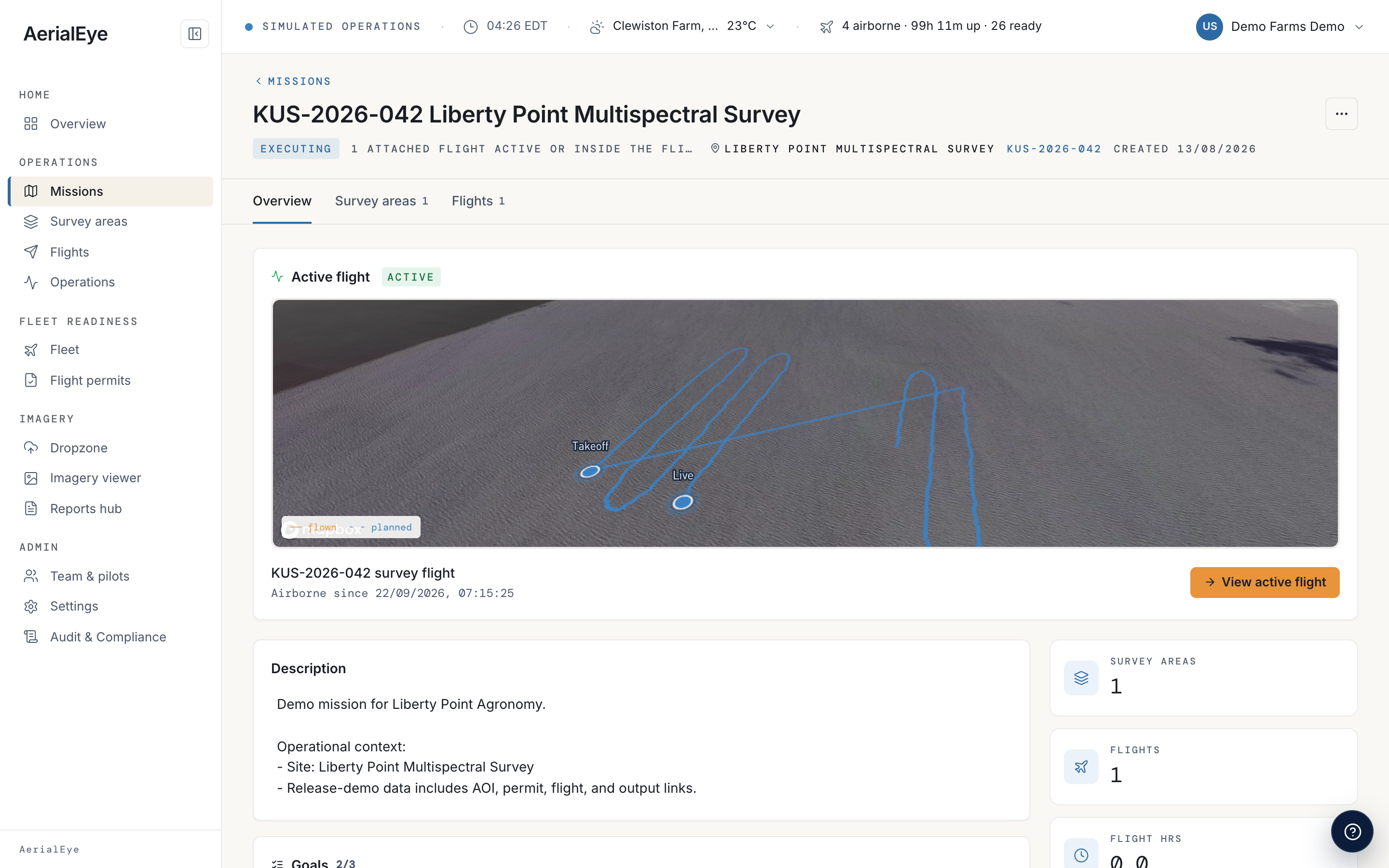
Map-based mission planning defines capture geometry and operational context. The route here is illustrative, not a flight authorisation.
Flight progress stays connected to the planned work.
Telemetry connects aircraft position with the mission record. The scene animates a sample flight rather than a live feed.
The output becomes the deliverable, rather than another disconnected file.
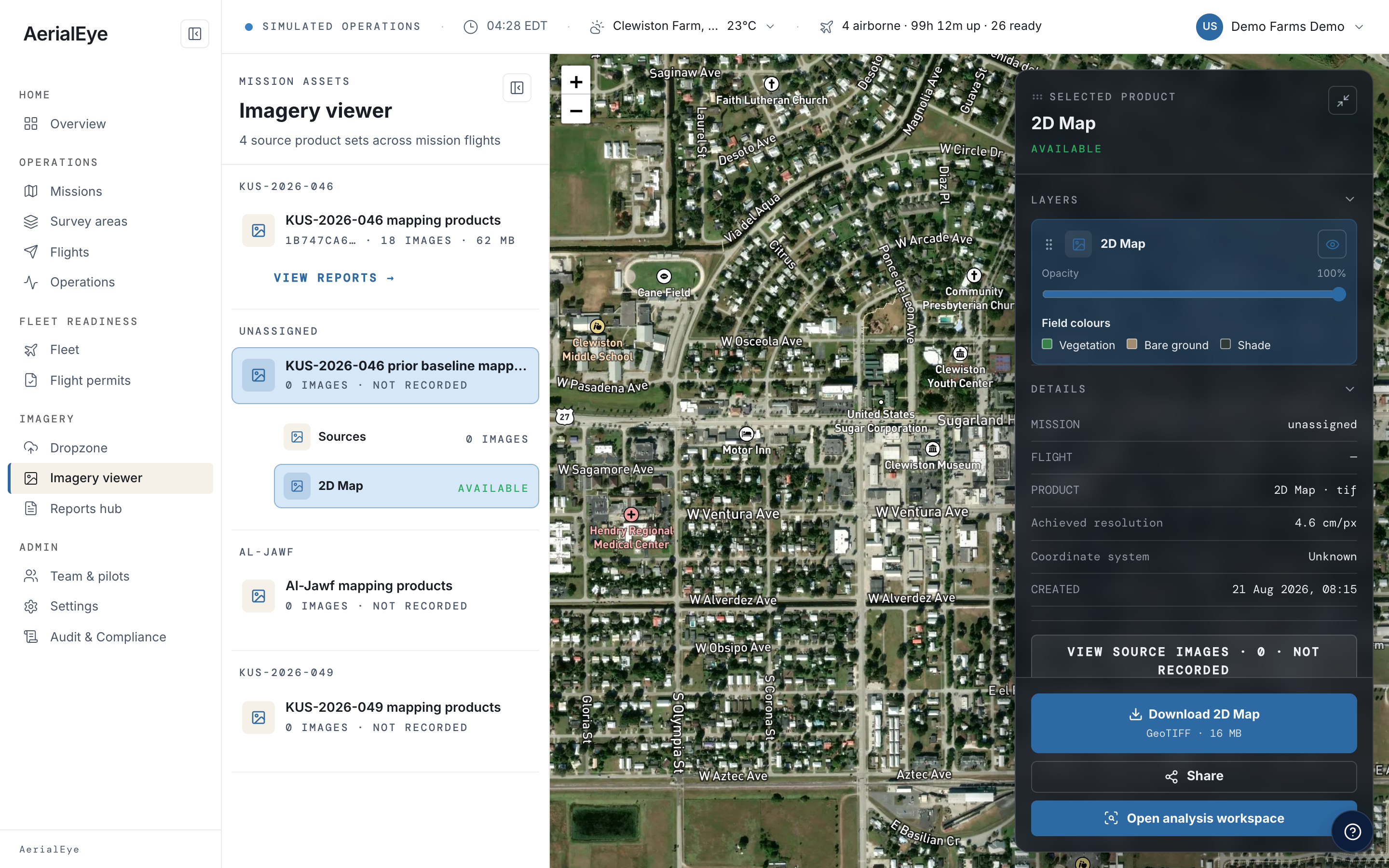
Photogrammetry produces orthomosaics, surface models and point clouds. The coloured surface illustrates an output; it does not process imagery.
Mission planning and survey imagery in the supplied product interface.
The Aerial Grid approach
Flight operations, aircraft health and survey delivery share one workflow. SkyTag connects the physical aircraft to that workflow, while local deployment keeps sensitive work on your infrastructure.
The hardware-to-software loop links SkyTag telemetry and vibration sensing with AerialEye operations and health analytics. Processing and delivery remain in the same platform, with on-premise deployment available.
Manage the job from capture to delivery.
AerialEye connects mission records, live telemetry, vibration-based health analytics, photogrammetry and delivery in a shared operational workflow. Cloud and on-premise deployment are available.
Interpret field surveys with vegetation indices.
AerialEye connects mission records, live telemetry, vibration-based health analytics, photogrammetry and delivery in a shared operational workflow. Cloud and on-premise deployment are available.
Keep missions, outputs, and client work together.
AerialEye connects mission records, live telemetry, vibration-based health analytics, photogrammetry and delivery in a shared operational workflow. Cloud and on-premise deployment are available.
Product details
Software for running drone jobs
Drone operations software
Maps, ground models and detailed 3D views
Orthomosaics, terrain and surface models, point clouds, and textured meshes
Use the cloud or your own infrastructure
Cloud or on-premise, scoped to operational requirements
SkyTag supplies location and health-monitoring data
SkyTag can provide position and aircraft data
Choose a deployment around your fleet and workload
Discuss fleet size, processing needs, and deployment with Aerial Grid
No. AerialEye carries the drone operation from planning through processing, delivery, and invoicing.
Mission records link capture, processing and delivery. Health and maintenance information add aircraft context to the operation.
The 3D survey is an illustration. Open AerialEye or book a demonstration to see the product workflow.
The demonstration uses procedural terrain and an animated aircraft. No photogrammetry computation or live telemetry is running here.
On-premise deployment is available. Data location and processing requirements should be confirmed for the deployment.
Confirm processing capacity, storage, access control and data location when scoping an on-premise deployment.
AerialEye
Talk to Aerial Grid about your requirements, availability, and deployment.